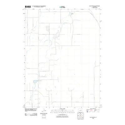
2010 Map of Klug Ranch
USGS Topo · Published 2010About this map
Box Elder Creek meanders through this agricultural landscape in Weld County, illustrating the vital water management systems of Colorado’s high plains. At the heart of the area, the Klug Ranch and its namesake water features, including Klug Lake and the Klug Number 3 Dam, reveal a landscape shaped by ranching interests and irrigation engineering. A dense grid of county roads, such as County Rd 36 and County Rd 55, provides access to the scattered farmsteads and open ranges characteristic of this region.
Find a feature on this map
24 named features on this map. Tap any name to fly to it.
Don’t see what you’re looking for? This feature index may not catch every label — zoom into the map to look around manually.
Map Details
Editions of this 2010 Klug Ranch Map
This is the sole edition of this map. No revisions or reprints were ever made.
Other maps of this area

1902 · Greeley
USGS Topo · 1:125,000

1949 · Hudson
USGS Topo · 1:24,000

1950 · Tampa
USGS Topo · 1:24,000

1950 · Keenesburg
USGS Topo · 1:24,000

1950 · Prospect Valley
USGS Topo · 1:24,000

1950 · Klug Ranch
USGS Topo · 1:24,000

1950 · Valley View School
USGS Topo · 1:24,000

1950 · Hardin
USGS Topo · 1:24,000
1950 · Milton Reservoir
USGS Topo · 1:24,000

1950 · La Salle
USGS Topo · 1:24,000