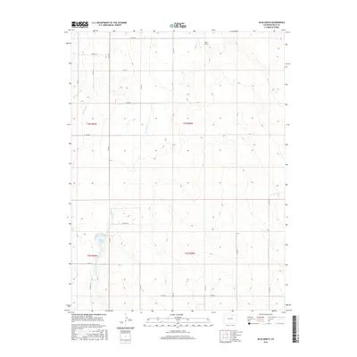
2016 Map of Klug Ranch
USGS Topo · Published 2016About this map
Klug Ranch and its namesake water features anchor this section of Weld County, reflecting the deep-rooted agricultural and ranching history of the High Plains. The landscape is defined by the management of water in an arid environment, where Box Elder Cr winds through the township lines and the irrigation network of the Neres Canal and W Neres Canal supports the surrounding sections. In the southwestern portion of the sheet, the storage capacity of Klug Reservoir Number 3 and Klug Lake highlights the importance of these localized catchments for the local ranching economy. This 2016 survey documents the grid of county roads, such as Co RD 49 and Co RD 34, that segment the territory into its legal townships including t3n r64w and t2n r65w.
Find a feature on this map
27 named features on this map. Tap any name to fly to it.
Don’t see what you’re looking for? This feature index may not catch every label — zoom into the map to look around manually.
Map Details
Editions of this 2016 Klug Ranch Map
This is the sole edition of this map. No revisions or reprints were ever made.
Other maps of this area

1902 · Greeley
USGS Topo · 1:125,000

1949 · Hudson
USGS Topo · 1:24,000

1950 · Tampa
USGS Topo · 1:24,000

1950 · Keenesburg
USGS Topo · 1:24,000

1950 · Prospect Valley
USGS Topo · 1:24,000

1950 · Klug Ranch
USGS Topo · 1:24,000

1950 · Valley View School
USGS Topo · 1:24,000

1950 · Hardin
USGS Topo · 1:24,000
1950 · Milton Reservoir
USGS Topo · 1:24,000

1950 · La Salle
USGS Topo · 1:24,000