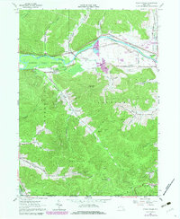
1979 Map of Knapp Creek
USGS Topo · Published 1980About this map
The Allegany Indian Reservation follows the wide sweep of the Allegheny River in this detailed look at southern Cattaraugus County near the Pennsylvania border. This landscape is a patchwork of industrial and recreational uses, where the Bradford Oil Field covers the southern hills with a dense network of gas and oil wells. The river valley serves as the primary corridor for transportation and settlement, housing the Conrail line and hamlets like Vandalia and South Vandalia. In the highlands, Mount Moriah overlooks the rugged terrain of Allegany State Park, while smaller settlements such as Knapp Creek and Chipmunk are tucked into the narrow valleys. The presence of St Johns Ch and Sacred Heart Ch anchors these rural communities, providing valuable coordinates for genealogists tracing local family histories in this corner of the Enchanted Mountains.
Find a feature on this map
53 named features on this map. Tap any name to fly to it.
Don’t see what you’re looking for? This feature index may not catch every label — zoom into the map to look around manually.
Map Details
Editions of this 1979 Knapp Creek Map
This is the sole edition of this map. No revisions or reprints were ever made.
Other maps of this area

1898 · Olean
USGS Topo · 1:62,500

1900 · Salamanca
USGS Topo · 1:62,500

1924 · Bradford
USGS Topo · 1:62,500

1926 · Bradford
USGS Topo · 1:62,500

1933 · Smethport
USGS Topo · 1:62,500

1937 · Smethport
USGS Topo · 1:62,500

1938 · Salamanca
USGS Topo · 1:62,500

1938 · Olean
USGS Topo · 1:62,500

1941 · Bradford
USGS Topo · 1:62,500

1943 · Olean
USGS Topo · 1:62,500