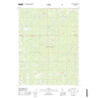
2018 Map of Kneecap Ridge
USGS Topo · Published 2018About this map
Mendocino National Forest defines the character of this 2018 survey, which documents a landscape of dramatic verticality where the Eel River and its tributaries carve through the northern California backcountry. High peaks and expansive ridgelines like Kneecap Ridge, Bear Wallow Ridge, and Gibson Ridge dominate the terrain, illustrating the complex watershed system feeding Spanish Cr and Corbin Cr. The area is marked by distinctive natural landmarks such as The Basin and Gravelly Flat, alongside localized points of interest like Cold Spring. This topographic record provides an essential look at the remote interior of Lake and Glenn counties, tracing the network of forest routes including the Glenn Co Road and the Kneecap Cabbage Patch trail, which offer passage through the steep drainages and mountain summits of the Coastal Range.
Find a feature on this map
52 named features on this map. Tap any name to fly to it.
Don’t see what you’re looking for? This feature index may not catch every label — zoom into the map to look around manually.
Map Details
Editions of this 2018 Kneecap Ridge Map
This is the sole edition of this map. No revisions or reprints were ever made.
Other maps of this area

1919 · Elk Creek
USGS Topo · 1:62,500

1922 · Hullville
USGS Topo · 1:62,500

1948 · Elk Creek
USGS Topo · 1:62,500

1951 · Lake Pillsbury
USGS Topo · 1:62,500

1951 · Stonyford
USGS Topo · 1:62,500

1952 · Hull Mountain
USGS Topo · 1:62,500

1957 · Elk Creek
USGS Topo · 1:62,500

1957 · Ukiah
USGS Topo · 1:250,000

1960 · Ukiah
USGS Topo · 1:250,000

1967 · Plaskett Ridge
USGS Topo · 1:24,000