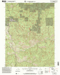
1996 Map of Kneecap Ridge
USGS Topo · Published 2001About this map
Mendocino National Forest defines the rugged character of this California landscape, where complex ridge systems and creek drainages create a remote terrain within Lake and Glenn counties. High-elevation landmarks such as Kneecap Ridge and Brushy Camp Ridge dominate the topography, interspersed with notable flatlands like Gravelly Flat. The map reveals the specific footprints of human history through the presence of the Provence Cabin (Site) and a lone Grave Site located near Bear Wallow. These isolated features, alongside drainage networks like the Middle Fork Stony Creek and Corbin Creek, illustrate the historical difficulty of accessing these high-country reaches. The Upper Lake Grindstone Rd serves as the primary artery through this forested region, connecting various springs and remote peaks like Little Round Mtn and High Point.
Find a feature on this map
33 named features on this map. Tap any name to fly to it.
Don’t see what you’re looking for? This feature index may not catch every label — zoom into the map to look around manually.
Map Details
Editions of this 1996 Kneecap Ridge Map
This is the sole edition of this map. No revisions or reprints were ever made.
Other maps of this area

1919 · Elk Creek
USGS Topo · 1:62,500

1922 · Hullville
USGS Topo · 1:62,500

1948 · Elk Creek
USGS Topo · 1:62,500

1951 · Lake Pillsbury
USGS Topo · 1:62,500

1951 · Stonyford
USGS Topo · 1:62,500

1952 · Hull Mountain
USGS Topo · 1:62,500

1957 · Elk Creek
USGS Topo · 1:62,500

1957 · Ukiah
USGS Topo · 1:250,000

1960 · Ukiah
USGS Topo · 1:250,000

1967 · Plaskett Ridge
USGS Topo · 1:24,000