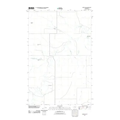
2011 Map of Knees NE
USGS Topo · Published 2011About this map
St Olaf Church stands as a primary landmark in this rural Chouteau County landscape, anchoring a region defined by agricultural water management and sparse prairie roads. The terrain is characterized by a series of small-scale impoundments with distinctive local names, including Gladiolus Dam, Kneeded Dam, and the humorously titled O'Lot O'Farmin' Dam. These features, along with Shotgun Slough, illustrate the vital importance of water storage for ranching and farming in north-central Montana. The road network, including Dugout Rd and Prairie Dr, follows a traditional grid pattern typical of the Great Plains, connecting remote homesteads and providing access to resources like the Hollandsworth Reservoir. This 2011 survey provides a detailed view of the localized infrastructure that sustains this high-plains environment.
Find a feature on this map
12 named features on this map. Tap any name to fly to it.
Don’t see what you’re looking for? This feature index may not catch every label — zoom into the map to look around manually.
Map Details
Editions of this 2011 Knees NE Map
This is the sole edition of this map. No revisions or reprints were ever made.
Other maps of this area

1954 · Shelby
USGS Topo · 1:250,000

1958 · Shelby
USGS Topo · 1:250,000

1970 · Carlson Coulee
USGS Topo · 1:24,000

1970 · Knees NE
USGS Topo · 1:24,000

1970 · Knees
USGS Topo · 1:24,000

1970 · Sollid School
USGS Topo · 1:24,000

1970 · Pondera School
USGS Topo · 1:24,000
1970 · Faris School
USGS Topo · 1:24,000
1970 · Mc Bridy Spring
USGS Topo · 1:24,000
1970 · Denson Ranch
USGS Topo · 1:24,000