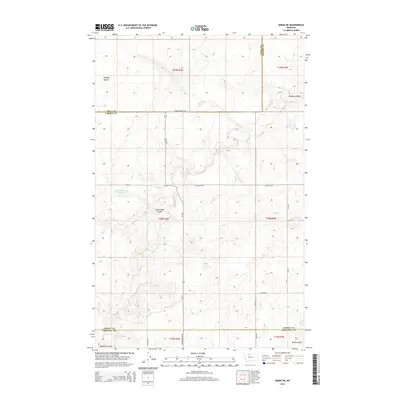
2014 Map of Knees NE
USGS Topo · Published 2014About this map
Hollandsworth Reservoir and the deep incisions of Dead Indian Coulee dominate this high plains landscape at the intersection of Toole, Liberty, and Chouteau Counties. The terrain is defined by a sparse but deliberate network of rural routes, including the historic path of S Bootlegger Trl and various section-line roads like Dugout Rd and 5700 Rd S. This 2014 survey reveals the persistent geometry of the Public Land Survey System, with township and range lines governing the placement of homestead-era relics and modern ranch access points. Water features such as Shotgun Slough and Pondera Coulee illustrate the drainage patterns of this semi-arid region, where every named landmark often points toward early ranching history or 19th-century transit corridors through the Montana territory.
Find a feature on this map
23 named features on this map. Tap any name to fly to it.
Don’t see what you’re looking for? This feature index may not catch every label — zoom into the map to look around manually.
Map Details
Editions of this 2014 Knees NE Map
This is the sole edition of this map. No revisions or reprints were ever made.
Other maps of this area

1954 · Shelby
USGS Topo · 1:250,000

1958 · Shelby
USGS Topo · 1:250,000

1970 · Carlson Coulee
USGS Topo · 1:24,000

1970 · Knees NE
USGS Topo · 1:24,000

1970 · Knees
USGS Topo · 1:24,000

1970 · Sollid School
USGS Topo · 1:24,000

1970 · Pondera School
USGS Topo · 1:24,000
1970 · Faris School
USGS Topo · 1:24,000
1970 · Mc Bridy Spring
USGS Topo · 1:24,000
1970 · Denson Ranch
USGS Topo · 1:24,000