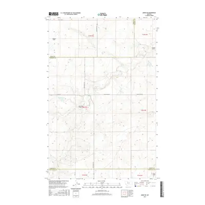
2017 Map of Knees NE
USGS Topo · Published 2017About this map
St Olaf Church stands as a primary landmark in this expansive agricultural corridor of North Central Montana, where the boundaries of Chouteau, Liberty, and Toole counties converge. The landscape is defined by the natural drainage of the High Plains, characterized by deep incisions like Dead Indian Coulee and Pondera Coulee. This 2017 survey illustrates a modern rural infrastructure built upon historic routes, most notably the Bootlegger Trl, which bisects the quadrangle from north to south. Water management is central to the area's utility, evidenced by the Hollandsworth Reservoir and the presence of Shotgun Slough. For the local historian or genealogist, the map provides a precise layout of section lines and township ranges that dictate the placement of local roads like Selma Rd and Dugout Coulee Rd, reflecting the enduring grid of the Public Land Survey System in this part of the state.
Find a feature on this map
12 named features on this map. Tap any name to fly to it.
Don’t see what you’re looking for? This feature index may not catch every label — zoom into the map to look around manually.
Map Details
Editions of this 2017 Knees NE Map
This is the sole edition of this map. No revisions or reprints were ever made.
Other maps of this area

1954 · Shelby
USGS Topo · 1:250,000

1958 · Shelby
USGS Topo · 1:250,000

1970 · Carlson Coulee
USGS Topo · 1:24,000

1970 · Knees NE
USGS Topo · 1:24,000

1970 · Knees
USGS Topo · 1:24,000

1970 · Sollid School
USGS Topo · 1:24,000

1970 · Pondera School
USGS Topo · 1:24,000
1970 · Faris School
USGS Topo · 1:24,000
1970 · Mc Bridy Spring
USGS Topo · 1:24,000
1970 · Denson Ranch
USGS Topo · 1:24,000