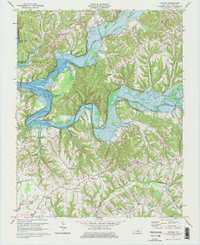
1970 Map of Knifley
USGS Topo · Published 1976About this map
Green River Lake dominates the northern half of this landscape, its expansive waters filling the valley where the Green River meets Casey Creek and White Oak Creek. The 1970 revision captures a transitional moment for Adair County, documenting the significant impact of the reservoir on local geography. While the community of Knifley remains established on higher ground to the north, many historical structures and road networks are shown just above the water line or following the new shoreline. To the south, the topography rises into a series of prominent ridges, including Burton Ridge and Camel Ridge. This area is dotted with small rural landmarks that provide a clear picture of the mid-century social fabric, including several country churches like Little Cake Ch and Bloomington Chapel, alongside schools such as Shepherd Sch and Stillhouse Ridge School.
Find a feature on this map
52 named features on this map. Tap any name to fly to it.
Don’t see what you’re looking for? This feature index may not catch every label — zoom into the map to look around manually.
Map Details
Editions of this 1970 Knifley Map
2 editions found
Other maps of this area

1952 · Clementsville
USGS Topo · 1:24,000

1952 · Mannsville
USGS Topo · 1:24,000

1953 · Campbellsville
USGS Topo · 1:24,000

1953 · Montpelier
USGS Topo · 1:24,000

1953 · Dunnville
USGS Topo · 1:24,000

1953 · Cane Valley
USGS Topo · 1:24,000

1954 · Knifley
USGS Topo · 1:24,000

1954 · Columbia
USGS Topo · 1:24,000

1954 · Russell Springs
USGS Topo · 1:24,000

1957 · Winchester
USGS Topo · 1:250,000