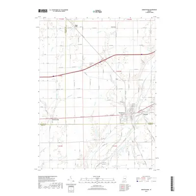
2019 Map of Knightstown
USGS Topo · Published 2019About this map
Knightstown and its neighboring settlements occupy the boundary lands where Hancock, Henry, and Rush Counties meet. This 2019 survey documents the enduring agricultural landscape of central Indiana, anchored by the Big Blue River and its numerous tributaries such as Montgomery Cr and Threemile Creek. The map provides significant genealogical value through its depiction of several local burial grounds, including Glencove Cem and the small Carthage Cem to the south. The transition from established village centers like Charlottesville and Raysville to outlying hamlets like Grant City and Maple Valley reflects the region's long-standing township-and-range settlement pattern. Researchers can trace the modern road network against older waterways like Sixmile Cr and Buck Cr, seeing how contemporary development aligns with the historic drainage of the Indiana plains.
Find a feature on this map
122 named features on this map. Tap any name to fly to it.
Don’t see what you’re looking for? This feature index may not catch every label — zoom into the map to look around manually.
Map Details
Editions of this 2019 Knightstown Map
This is the sole edition of this map. No revisions or reprints were ever made.
Other maps of this area

1949 · New Castle West
USGS Topo · 1:24,000

1950 · Dunreith
USGS Topo · 1:24,000

1953 · Pendleton
USGS Topo · 1:24,000

1953 · Cincinnati
USGS Topo · 1:250,000

1956 · Cleveland
USGS Topo · 1:24,000

1956 · Morristown
USGS Topo · 1:24,000

1957 · Cincinnati
USGS Topo · 1:250,000

1959 · Mays
USGS Topo · 1:24,000

1960 · New Castle West
USGS Topo · 1:24,000
1960 · Carthage
USGS Topo · 1:24,000