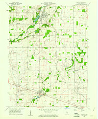
1960 Map of Carthage
USGS Topo · Published 1961About this map
Carthage sits along the Big Blue River in this early 1960s survey of northwestern Rush County, serving as a focal point for the region's agricultural and industrial infrastructure. The landscape is defined by its drainage networks, where the river meets Ripley Creek and Carthage Creek, and by the presence of a Gaging Sta and Pumping Sta near the town center. The map reveals a highly structured rural society, with New York Central and Baltimore and Ohio rail lines cutting through the townships of Posey, Jackson, and Center. Local social centers are anchored by landmarks such as Walnut Ridge Ch and Township Sch. Numerous Gas Wells scattered across the fields highlight the area's subterranean resources, while the network of named ditches like Fearless Ditch and New House Ditch illustrates the extensive efforts to manage the tillable land.
Find a feature on this map
54 named features on this map. Tap any name to fly to it.
Don’t see what you’re looking for? This feature index may not catch every label — zoom into the map to look around manually.
Map Details
Editions of this 1960 Carthage Map
2 editions found
Other maps of this area

1950 · Dunreith
USGS Topo · 1:24,000

1953 · Cincinnati
USGS Topo · 1:250,000

1956 · Cleveland
USGS Topo · 1:24,000

1956 · Morristown
USGS Topo · 1:24,000

1956 · Rays Crossing
USGS Topo · 1:24,000

1957 · Cincinnati
USGS Topo · 1:250,000

1959 · Rushville
USGS Topo · 1:24,000

1959 · Mays
USGS Topo · 1:24,000
1960 · Manilla
USGS Topo · 1:24,000
1960 · Knightstown
USGS Topo · 1:24,000