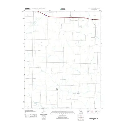
2011 Map of Knob Noster NW
USGS Topo · Published 2011About this map
Ernestville and Mount Olive anchor this agricultural landscape in Lafayette County, where a dense network of country roads connects family farms and local landmarks. The terrain is defined by the branching tributaries of the Missouri River watershed, most notably the meandering paths of Mulkey Creek and Flagstaff Creek. To the north, the Old Channel Davis Creek suggests a landscape shaped by historical water management or natural shifts in the stream's course. Genealogy researchers can find point-specific data at Foster Cemetery near the base of Rattlesnake Hill, as well as New Hope Cemetery located further north near Peavine Creek. The map documents a rural Missouri community at the start of the 2010s, balancing modern infrastructure like the prominent east-west highway corridor with secluded features such as Lake Pajastka in the southwest corner.
Find a feature on this map
65 named features on this map. Tap any name to fly to it.
Don’t see what you’re looking for? This feature index may not catch every label — zoom into the map to look around manually.
Map Details
Editions of this 2011 Knob Noster NW Map
This is the sole edition of this map. No revisions or reprints were ever made.
Other maps of this area

1885 · Warrensburg
USGS Topo · 1:125,000

1887 · Warrensburg
USGS Topo · 1:125,000

1889 · Lexington
USGS Topo · 1:125,000

1894 · Warrensburg
USGS Topo · 1:125,000

1917 · Knobnoster
USGS Topo · 1:62,500

1947 · Jefferson City
USGS Topo · 1:250,000

1949 · Mayview
USGS Topo · 1:24,000

1950 · Mayview
USGS Topo · 1:24,000

1951 · Alma
USGS Topo · 1:24,000
1951 · Higginsville
USGS Topo · 1:24,000