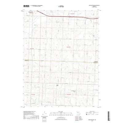
2017 Map of Knob Noster NW
USGS Topo · Published 2017About this map
Higginsville anchors the northwest corner of this agricultural landscape in Lafayette and Johnson Counties, where the Missouri prairie is defined by a complex network of meandering drainage systems. The northern sections are dominated by the Old Channel Davis Cr and Mulkey Cr, while the southern reaches feature the headwaters of Flagstaff Cr and the secluded Lake Pajaszka. Small rural nodes like Mount Olive and Ernestville serve as traditional landmarks amidst a grid of section-line roads, many of which carry family and local names such as Theiman Rd and Meinershagen Rd. The topography is generally gentle, though notable elevations like Rattlesnake Hill rise near the Foster Cem. This 2017 survey reflects the modern rural layout while preserving the placement of older community markers like the New Hope Cem and the route of Old Hwy 40.
Find a feature on this map
84 named features on this map. Tap any name to fly to it.
Don’t see what you’re looking for? This feature index may not catch every label — zoom into the map to look around manually.
Map Details
Editions of this 2017 Knob Noster NW Map
This is the sole edition of this map. No revisions or reprints were ever made.
Other maps of this area

1885 · Warrensburg
USGS Topo · 1:125,000

1887 · Warrensburg
USGS Topo · 1:125,000

1889 · Lexington
USGS Topo · 1:125,000

1894 · Warrensburg
USGS Topo · 1:125,000

1917 · Knobnoster
USGS Topo · 1:62,500

1947 · Jefferson City
USGS Topo · 1:250,000

1949 · Mayview
USGS Topo · 1:24,000

1950 · Mayview
USGS Topo · 1:24,000

1951 · Alma
USGS Topo · 1:24,000
1951 · Higginsville
USGS Topo · 1:24,000