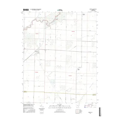
2017 Map of Knobel
USGS Topo · Published 2017About this map
The town of Knobel and the community of Walnut Grove anchor this 2017 survey of the Arkansas lowlands near the Clay Co Greene Co border. The landscape is defined by its complex water management and drainage systems, featuring the meandering course of the Black River in the northwest and engineered waterways like Kramer Ditch and Cache River Ditch Number 1. These systems were critical for reclaiming the swampy bottomlands for agricultural use, a process reflected in the numerous named sloughs and backwaters such as Long Lake, Poyner Lake, and the curiously named Flywait Back Out. For those researching local family history, several small burial grounds are documented, including Bond Cem, Saint Bernard Cem, and Gilchrist Cem. The map illustrates the grid-based rural road network, with routes like Copeland Rd and various Clay County roads connecting isolated farmsteads across the flat, fertile terrain of the Mississippi Embayment.
Find a feature on this map
54 named features on this map. Tap any name to fly to it.
Don’t see what you’re looking for? This feature index may not catch every label — zoom into the map to look around manually.
Map Details
Editions of this 2017 Knobel Map
This is the sole edition of this map. No revisions or reprints were ever made.
Other maps of this area

1935 · Rector
USGS Topo · 1:62,500

1935 · Knobel
USGS Topo · 1:62,500

1940 · Gainesville
USGS Topo · 1:62,500

1940 · Marmaduke
USGS Topo · 1:62,500

1941 · Knobel
USGS Topo · 1:62,500

1957 · Poplar Bluff
USGS Topo · 1:250,000

1958 · Marmaduke
USGS Topo · 1:62,500

1958 · Gainesville
USGS Topo · 1:62,500

1958 · Rector
USGS Topo · 1:62,500

1959 · Poplar Bluff
USGS Topo · 1:250,000