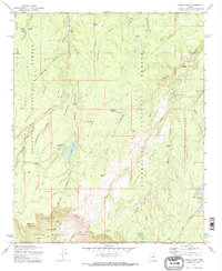
1972 Map of Knoll Lake
USGS Topo · Published 1974About this map
Limestone Ranch and isolated outposts like O Haco Cabins define the high-country settlement pattern of this Coconino National Forest region during the early 1970s. The landscape is characterized by a sophisticated water management network essential for ranching and recreation, ranging from the prominent Knoll Lake to smaller developments such as Limestone Tank, Dines Tank, and Knoll Tank. These features suggest a reliance on seasonal moisture and spring-fed resources in a high-elevation environment. The presence of Campo Bonito and various cabin sites underscores the area's dual role as a working landscape for livestock and a destination for forest visitors. Local history researchers can trace the distribution of these specific landmarks across a terrain marked by numerous springs, including Double Cabin Spring and Gentry Spring, which likely served as critical focal points for both early settlers and forest management operations.
Find a feature on this map
9 named features on this map. Tap any name to fly to it.
Don’t see what you’re looking for? This feature index may not catch every label — zoom into the map to look around manually.
Map Details
Editions of this 1972 Knoll Lake Map
2 editions found
Other maps of this area

1886 · Holbrook
USGS Topo · 1:250,000

1887 · Verde
USGS Topo · 1:250,000

1892 · Verde
USGS Topo · 1:250,000

1893 · Holbrook
USGS Topo · 1:250,000

1934 · Promontory Butte
USGS Topo · 1:62,500

1939 · Promontory Butte
USGS Topo · 1:62,500

1952 · Promontory Butte
USGS Topo · 1:62,500

1954 · Holbrook
USGS Topo · 1:250,000

1957 · Holbrook
USGS Topo · 1:250,000

1958 · Holbrook
USGS Topo · 1:250,000