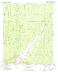
1972 Map of Knoll Lake
USGS Topo · Published 1974About this map
The Mogollon Rim forms a dramatic topographical boundary on this 1972 survey, marking the transition between the high plateau of the Coconino National Forest and the deep canyons of the Tonto National Forest. This high-country landscape is defined by its water management and wilderness infrastructure, featuring essential ranching and survival landmarks such as Limestone Tank, Jumping Spring, and the O'Haco Lookout Tower. The northern portion of the map is dominated by the complex drainage systems of Leonard Canyon and Buck Springs Ridge, while the south reveals the steep drop-offs of the rim near the Tonto State Fish Hatchery.
Find a feature on this map
60 named features on this map. Tap any name to fly to it.
Don’t see what you’re looking for? This feature index may not catch every label — zoom into the map to look around manually.
Map Details
Editions of this 1972 Knoll Lake Map
2 editions found
Other maps of this area

1886 · Holbrook
USGS Topo · 1:250,000

1887 · Verde
USGS Topo · 1:250,000

1892 · Verde
USGS Topo · 1:250,000

1893 · Holbrook
USGS Topo · 1:250,000

1934 · Promontory Butte
USGS Topo · 1:62,500

1939 · Promontory Butte
USGS Topo · 1:62,500

1952 · Promontory Butte
USGS Topo · 1:62,500

1954 · Holbrook
USGS Topo · 1:250,000

1957 · Holbrook
USGS Topo · 1:250,000

1958 · Holbrook
USGS Topo · 1:250,000