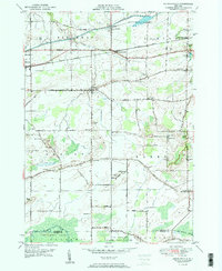
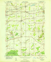
1950 Map of Knowlesville
USGS Topo · Published 1950About this map
The Erie Canal cuts through the northern landscape of Orleans County, running parallel to the New York Central railroad and defining the industrial and transit corridor between Medina and Knowlesville. This mid-century survey captures a rural landscape transitioning toward specialized agricultural use, evidenced by the numerous district schools and local cemeteries that dot the countryside, such as East Shelby Cem and the Christian Cem. To the south, the terrain shifts into the marshy lowland of Oak Orchard Swamp, where the Oak Orchard State Game Refuge marks a dedicated conservation area at the border of Orleans and Genesee counties. The network of local roads like Maple Ridge Road and Telegraph Road connects small communities like Millville and East Shelby, following the subtle elevations of the Ridgeway and Albion townships.
Find a feature on this map
73 named features on this map. Tap any name to fly to it.
Don’t see what you’re looking for? This feature index may not catch every label — zoom into the map to look around manually.
Map Details
Editions of this 1950 Knowlesville Map
3 editions found
Other maps of this area

1897 · Albion
USGS Topo · 1:62,500

1897 · Medina
USGS Topo · 1:62,500

1897 · Oak Orchard
USGS Topo · 1:62,500

1897 · Ridgeway
USGS Topo · 1:62,500

1944 · Ashwood
USGS Topo · 1:31,680

1944 · Albion
USGS Topo · 1:31,680

1949 · Kendall
USGS Topo · 1:62,500
1949 · Akron
USGS Topo · 1:24,000
1949 · Medina
USGS Topo · 1:24,000
1950 · Knowlesville
USGS Topo · 1:24,000