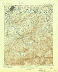
1901 Map of Knoxville
USGS Topo · Published 1945About this map
The Tennessee River and French Broad River converge at Knoxville, anchoring a landscape defined by river-based transport and the rise of the Great Smoky Mountains. This survey shows the region decades before it became a national park, capturing independent mountain communities like Cade Cove and Gatlinburg in their early development. Down in the valleys, the Knoxville and Augusta RR connects Maryville and Rockford to the regional hub, while numerous crossings such as Ramsey Ferry and Underdown Ferry facilitate movement where bridges had yet to span the wider reaches. Higher elevations are marked by traditional landmarks like Gregory Bald and Silers Bald, alongside smaller settlements like Tuckaleeche and Pigeon Forge. This map preserves the 19th-century settlement patterns of the East Tennessee highlands, including local schools like Porter Academy and crossroads such as Henry X Roads.
Find a feature on this map
120 named features on this map. Tap any name to fly to it.
Don’t see what you’re looking for? This feature index may not catch every label — zoom into the map to look around manually.
Map Details
Editions of this 1901 Knoxville Map
5 editions found

Other maps of this area

1883 · Morristown
USGS Topo · 1:125,000

1886 · Knoxville
USGS Topo · 1:125,000

1891 · Cowee
USGS Topo · 1:125,000

1892 · Knoxville
USGS Topo · 1:125,000

1893 · Mt Guyot
USGS Topo · 1:125,000

1893 · Morristown
USGS Topo · 1:125,000

1893 · Murphy
USGS Topo · 1:125,000

1893 · Briceville
USGS Topo · 1:125,000

1894 · Knoxville
USGS Topo · 1:125,000

1895 · Morristown
USGS Topo · 1:125,000