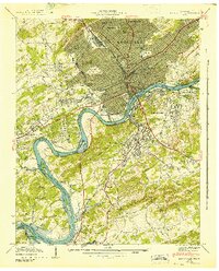
1942 Map of Knoxville
USGS Topo · Published 1942About this map
Knoxville sits at a pivotal moment in its development during this early 1940s survey, defined by the winding course of the Tennessee River and the newly designated Fort Loudon Reservoir. The urban landscape is dense with civic and educational institutions, from the sprawling grounds of the University of Tennessee and its Dept of Agriculture to Knoxville College and the State School for Deaf on Island Home. Transport networks are heavily established, featuring major hubs like the L & N Station and Southern Station, alongside local industries like the Brick Kilns near McNutt Shoals.
Find a feature on this map
116 named features on this map. Tap any name to fly to it.
Don’t see what you’re looking for? This feature index may not catch every label — zoom into the map to look around manually.
Map Details
Editions of this 1942 Knoxville Map
This is the sole edition of this map. No revisions or reprints were ever made.
Other maps of this area

1886 · Knoxville
USGS Topo · 1:125,000

1892 · Knoxville
USGS Topo · 1:125,000

1893 · Briceville
USGS Topo · 1:125,000

1894 · Knoxville
USGS Topo · 1:125,000

1895 · Loudon
USGS Topo · 1:125,000

1895 · Briceville
USGS Topo · 1:125,000

1895 · Knoxville
USGS Topo · 1:125,000

1896 · Briceville
USGS Topo · 1:125,000

1897 · Maynardville
USGS Topo · 1:125,000

1900 · Maynardville
USGS Topo · 1:125,000