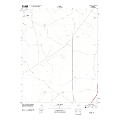
2010 Map of Koehler
USGS Topo · Published 2010About this map
Ox Canyon Mine and the settlement of Koehler sit at the mouth of Prairie Crow Canyon, marking a landscape defined by industrial history and water management in Colfax County. In this high plains environment, the flow of Crow Creek and Falls Creek is controlled by infrastructure like the Koehler Dam, which forms Koehler Lake. The importance of irrigation and water transport is evident in the presence of the Eagle Tail Canal, which snakes through the eastern portion of the quadrangle toward the Canadian River.
Find a feature on this map
20 named features on this map. Tap any name to fly to it.
Don’t see what you’re looking for? This feature index may not catch every label — zoom into the map to look around manually.
Map Details
Editions of this 2010 Koehler Map
This is the sole edition of this map. No revisions or reprints were ever made.
Other maps of this area

1912 · Raton
USGS Topo · 1:62,500

1914 · Raton
USGS Topo · 1:62,500

1915 · Brilliant
USGS Topo · 1:62,500

1915 · Koehler
USGS Topo · 1:62,500

1917 · Koehler
USGS Topo · 1:62,500

1954 · Raton
USGS Topo · 1:250,000

1958 · Raton
USGS Topo · 1:250,000

1971 · Clifton House
USGS Topo · 1:24,000

1971 · Saltpeter Mountain
USGS Topo · 1:24,000
1971 · Curtis Camp
USGS Topo · 1:24,000