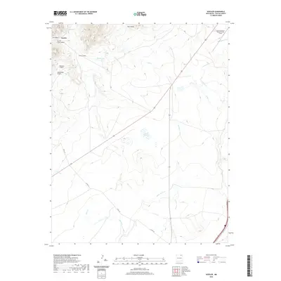
2020 Map of Koehler
USGS Topo · Published 2020About this map
Koehler sits at the foot of the high plains in Colfax County, where the dramatic terrain of Ox Canyon and Crow Canyon meets the expansive drainage of the Springer Arroyo. This modern survey documents a landscape defined by water management and aviation, featuring the Eagle Tail Canal and the Raton Municipal Airport/Crews Field in the northeast. The area is characterized by several named canyons including Beardon Canyon and Ashenfelder Canyon, which feed into local water bodies like Koehler Lake and Dorsey Lake. The map provides a clear view of the rural infrastructure, from the winding path of Curtis Cr to the established routes of Co RD A-45, reflecting the contemporary character of this high-elevation region.
Find a feature on this map
18 named features on this map. Tap any name to fly to it.
Don’t see what you’re looking for? This feature index may not catch every label — zoom into the map to look around manually.
Map Details
Editions of this 2020 Koehler Map
This is the sole edition of this map. No revisions or reprints were ever made.
Other maps of this area

1912 · Raton
USGS Topo · 1:62,500

1914 · Raton
USGS Topo · 1:62,500

1915 · Brilliant
USGS Topo · 1:62,500

1915 · Koehler
USGS Topo · 1:62,500

1917 · Koehler
USGS Topo · 1:62,500

1954 · Raton
USGS Topo · 1:250,000

1958 · Raton
USGS Topo · 1:250,000

1971 · Clifton House
USGS Topo · 1:24,000

1971 · Saltpeter Mountain
USGS Topo · 1:24,000
1971 · Curtis Camp
USGS Topo · 1:24,000