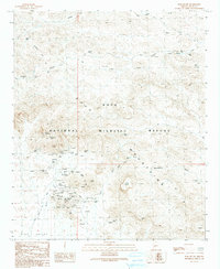
1990 Map of Kofa Butte
USGS Topo · Published 1990About this map
Mining operations and desert water sources define this 1990 provisional survey of the Kofa Mountains within the Kofa National Wildlife Refuge. The landscape is heavily marked by the region's hard-rock history, centered on the King of Arizona Mine and the North Star Mine. A network of adits, mine shafts, and open pit mines covers the foothills of Polaris Mountain and Kofa Butte, telling the story of a rugged mineral economy. Infrastructure for the arid climate is visible through numerous wells and catchments such as Raven Tank, King Well, and Kofa Dam. A solitary Cemetery near the Black Dahlia Mine provides a poignant genealogical connection to the miners and prospectors who once worked these claims along the King Road.
Find a feature on this map
46 named features on this map. Tap any name to fly to it.
Don’t see what you’re looking for? This feature index may not catch every label — zoom into the map to look around manually.
Map Details
Editions of this 1990 Kofa Butte Map
This is the sole edition of this map. No revisions or reprints were ever made.
Other maps of this area

1942 · Blythe
USGS Topo · 1:250,000

1942 · Vicksburg
USGS Topo · 1:250,000

1954 · Salton Sea
USGS Topo · 1:250,000

1954 · Phoenix
USGS Topo · 1:250,000

1955 · Salton Sea
USGS Topo · 1:250,000

1957 · Phoenix
USGS Topo · 1:250,000

1958 · Phoenix
USGS Topo · 1:250,000

1959 · Salton Sea
USGS Topo · 1:250,000

1960 · Phoenix
USGS Topo · 1:250,000

1962 · Kofa Butte
USGS Topo · 1:62,500