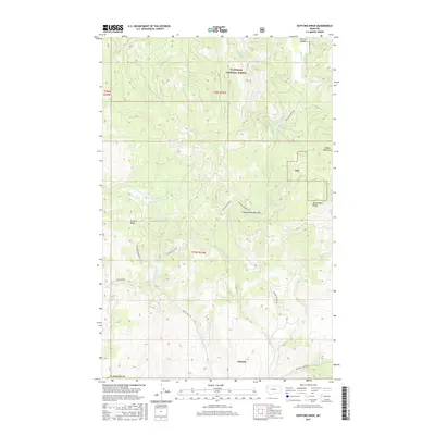
2017 Map of Kofford Ridge
USGS Topo · Published 2017About this map
Niarada sits at the southern edge of this mountain landscape, marking a transition point between the higher elevations and the drainage basins of the Salish Mountains. The map reveals a complex network of forest access and mining-related infrastructure, most notably the Flathead Mine Rd which winds through the central terrain towards the Hog Heaven Range. This area within the Flathead National Forest is defined by its ridge-and-valley topography, with Kofford Ridge dominating the western portion and Browns Meadow Pass providing a critical crossing point near Browns Meadow. Watercourses like Little Meadow Cr and Sullivan Cr carve out the drainages that likely dictated early travel routes. The presence of Battle Butte Rd and Cromwell Creek RD further illustrates the established road network serving the timber and mineral interests of Flathead County.
Find a feature on this map
23 named features on this map. Tap any name to fly to it.
Don’t see what you’re looking for? This feature index may not catch every label — zoom into the map to look around manually.
Map Details
Editions of this 2017 Kofford Ridge Map
This is the sole edition of this map. No revisions or reprints were ever made.
Other maps of this area

1920 · Flathead Lake
USGS Topo · 1:125,000

1943 · Kalispell
USGS Topo · 1:125,000

1956 · Wallace
USGS Topo · 1:250,000

1957 · Kalispell
USGS Topo · 1:250,000

1960 · Kalispell
USGS Topo · 1:250,000

1960 · Wallace
USGS Topo · 1:250,000

1961 · Kalispell
USGS Topo · 1:250,000

1962 · Kila
USGS Topo · 1:24,000

1964 · Irvine Lookout Tower
USGS Topo · 1:24,000
1964 · Lake Mary Ronan
USGS Topo · 1:24,000