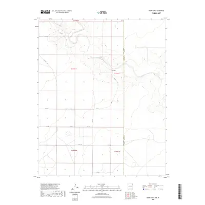
2020 Map of Koger Ranch
USGS Topo · Published 2020About this map
Tramperos Creek meanders across this high plains landscape of northeast New Mexico, where the state boundary meets the Texas Panhandle. The map centers on the namesake Koger Ranch, a focal point of rural life in this remote portion of Union County. The terrain is characterized by broad drainage basins like Punta de Agua Creek and a sparse grid of ranch-to-market roads, including Romero Rd and Hall Rd. These arterial paths reflect the expansive land-management patterns typical of the region's cattle-ranching heritage. Surveyed with 10-foot contour intervals, the map reveals the subtle topographical shifts of the High Plains, providing a precise record of watercourses and section lines as they existed in the early twenty-first century.
Find a feature on this map
21 named features on this map. Tap any name to fly to it.
Don’t see what you’re looking for? This feature index may not catch every label — zoom into the map to look around manually.
Map Details
Editions of this 2020 Koger Ranch Map
This is the sole edition of this map. No revisions or reprints were ever made.
Other maps of this area

1954 · Tucumcari
USGS Topo · 1:250,000

1954 · Dalhart
USGS Topo · 1:250,000

1958 · Tucumcari
USGS Topo · 1:250,000

1958 · Dalhart
USGS Topo · 1:250,000

1962 · Dalhart
USGS Topo · 1:250,000

1970 · Stead
USGS Topo · 1:24,000

1970 · Sedan SE
USGS Topo · 1:24,000

1971 · Koger Ranch
USGS Topo · 1:24,000

1971 · Centerville Corner
USGS Topo · 1:24,000

1971 · Amistad SE
USGS Topo · 1:24,000