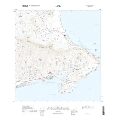
2017 Map of Koko Head
USGS Topo · Published 2017About this map
Waimanalo and the eastern ridges of O'ahu are defined by a complex network of valleys and coastal development along the windward and leeward shores. To the north, the Maunawili Valley is carved out between Olomana Ridge and the heights of the Ko'olau Range, featuring critical water infrastructure like the Kailua Ditch and Maunawili Ditch. The geography shifts dramatically across the range into the deeply incised Pia Valley, Kūpaua Valley, and Kuli'ou'ou Valley, which funnel toward the suburban expanses of East Honolulu. Along the southern coast, the development of Hawai'i Kai surrounds the modified Kuapā Pond, while the preserved marine environment of Hanauma Bay remains a prominent landmark. This 2017 survey details the dense modern street grids of Portlock and 'Āina Haina contrasted against the precipitous terrain of Kamehame Ridge and the volcanic caldera at Ka'au Crater.
Find a feature on this map
209 named features on this map. Tap any name to fly to it.
Don’t see what you’re looking for? This feature index may not catch every label — zoom into the map to look around manually.
Map Details
Editions of this 2017 Koko Head Map
This is the sole edition of this map. No revisions or reprints were ever made.
Other maps of this area

1952 · Koko Head
USGS Topo · 1:24,000

1952 · Mokapu
USGS Topo · 1:24,000

1953 · Honolulu
USGS Topo · 1:24,000

1954 · Oahu
USGS Topo · 1:250,000

1954 · Kaneohe
USGS Topo · 1:24,000

1959 · Mokapu
USGS Topo · 1:24,000

1959 · Koko Head
USGS Topo · 1:24,000

1959 · Kaneohe
USGS Topo · 1:24,000

1959 · Honolulu
USGS Topo · 1:24,000

1961 · Oahu
USGS Topo · 1:250,000