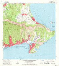
1969 Map of Koko Head
USGS Topo · Published 1971About this map
The southeastern tip of Oahu is dominated by the volcanic forms of Koko Crater and Koko Head, creating a landscape where residential expansion meets protected natural reserves. During the late 1960s, the development of Hawaii Kai was transforming the area around Kuapa Pond, signaling a shift from rural coastal lands to planned suburban communities. Along the windward shore, Waimanalo Beach and the Bellows Air Force Station (Inactive) occupy the lowlands beneath the sheer cliffs of the Koolau Range. This era captures the transition of the Koolaupoko and Honolulu Districts, where large institutional sites like the Kawailoa Girls Home and the University of Hawaii Solar Observatory stood alongside growing neighborhoods like Aina Haina and Niu Valley. The map also details offshore features including Manana Island and the famous Halona Point Blowhole.
Find a feature on this map
82 named features on this map. Tap any name to fly to it.
Don’t see what you’re looking for? This feature index may not catch every label — zoom into the map to look around manually.
Map Details
Editions of this 1969 Koko Head Map
This is the sole edition of this map. No revisions or reprints were ever made.
Other maps of this area

1952 · Koko Head
USGS Topo · 1:24,000

1952 · Mokapu
USGS Topo · 1:24,000

1953 · Honolulu
USGS Topo · 1:24,000

1954 · Oahu
USGS Topo · 1:250,000

1954 · Kaneohe
USGS Topo · 1:24,000

1959 · Mokapu
USGS Topo · 1:24,000

1959 · Koko Head
USGS Topo · 1:24,000

1959 · Kaneohe
USGS Topo · 1:24,000

1959 · Honolulu
USGS Topo · 1:24,000

1961 · Oahu
USGS Topo · 1:250,000