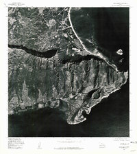
1978 Map of Koko Head
USGS Topo · Published 1981About this map
Koko Head and the surrounding coastline of southeastern Oahu are captured in this late-1970s orthophotograph, providing a detailed visual record of the land just as suburban expansion was defining the area. The imagery highlights the stark contrast between the steep, dramatic ridges of Olomana Peak and the expanding residential developments lining the shores of Maunalua Bay. Unlike traditional topographic maps, this photo-based survey reveals the exact texture of the 1970s landscape, from the individual rooftops and road networks of local neighborhoods to the offshore presence of Manana Island in the Pacific Ocean. This document serves as a valuable resource for tracing the physical growth of these coastal communities and the preservation of the prominent volcanic headlands during a period of rapid change in Hawaii.
Find a feature on this map
5 named features on this map. Tap any name to fly to it.
Don’t see what you’re looking for? This feature index may not catch every label — zoom into the map to look around manually.
Map Details
Editions of this 1978 Koko Head Map
This is the sole edition of this map. No revisions or reprints were ever made.
Other maps of this area

1952 · Koko Head
USGS Topo · 1:24,000

1952 · Mokapu
USGS Topo · 1:24,000

1953 · Honolulu
USGS Topo · 1:24,000

1954 · Oahu
USGS Topo · 1:250,000

1954 · Kaneohe
USGS Topo · 1:24,000

1959 · Mokapu
USGS Topo · 1:24,000

1959 · Koko Head
USGS Topo · 1:24,000

1959 · Kaneohe
USGS Topo · 1:24,000

1959 · Honolulu
USGS Topo · 1:24,000

1961 · Oahu
USGS Topo · 1:250,000