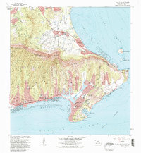
1983 Map of Koko Head
USGS Topo · Published 1983About this map
Koko Head and the volcanic shoreline of southeastern Oahu dominate this early 1980s topographical record. The transition from the steep ridges of the Honolulu Watershed Forest Reserve to the expanding residential developments of Hawaii Kai and Niu Valley illustrates the late-century suburban growth pattern of the island. Along the coast, the Kalanianaole Highway provides the primary artery connecting the windward and leeward sides, passing the notable Kuapa Pond and the strictly protected Koko Head State Underwater Park.
Find a feature on this map
54 named features on this map. Tap any name to fly to it.
Don’t see what you’re looking for? This feature index may not catch every label — zoom into the map to look around manually.
Map Details
Editions of this 1983 Koko Head Map
This is the sole edition of this map. No revisions or reprints were ever made.
Other maps of this area

1952 · Koko Head
USGS Topo · 1:24,000

1952 · Mokapu
USGS Topo · 1:24,000

1953 · Honolulu
USGS Topo · 1:24,000

1954 · Oahu
USGS Topo · 1:250,000

1954 · Kaneohe
USGS Topo · 1:24,000

1959 · Mokapu
USGS Topo · 1:24,000

1959 · Koko Head
USGS Topo · 1:24,000

1959 · Kaneohe
USGS Topo · 1:24,000

1959 · Honolulu
USGS Topo · 1:24,000

1961 · Oahu
USGS Topo · 1:250,000