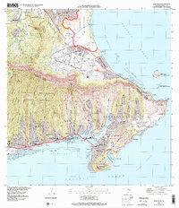
1999 Map of Koko Head
USGS Topo · Published 2000About this map
Hawai'i Kai and the eastern ridges of the Ko'olau Range define this 1999 landscape, where suburban expansion meets significant conservation zones. The residential developments of Niu Valley, Kuli'ou'ou, and Portlock occupy the floor of deep valleys separated by sharp ridges, all draining toward the waters of Maunalua Bay. The transformation of the coastal environment is most evident at Kuapa Pond, which has been engineered into a modern marina system, contrasting with the nearby protected Paiko Lagoon Wildlife Sanctuary.
Find a feature on this map
79 named features on this map. Tap any name to fly to it.
Don’t see what you’re looking for? This feature index may not catch every label — zoom into the map to look around manually.
Map Details
Editions of this 1999 Koko Head Map
This is the sole edition of this map. No revisions or reprints were ever made.
Other maps of this area

1952 · Koko Head
USGS Topo · 1:24,000

1952 · Mokapu
USGS Topo · 1:24,000

1953 · Honolulu
USGS Topo · 1:24,000

1954 · Oahu
USGS Topo · 1:250,000

1954 · Kaneohe
USGS Topo · 1:24,000

1959 · Mokapu
USGS Topo · 1:24,000

1959 · Koko Head
USGS Topo · 1:24,000

1959 · Kaneohe
USGS Topo · 1:24,000

1959 · Honolulu
USGS Topo · 1:24,000

1961 · Oahu
USGS Topo · 1:250,000