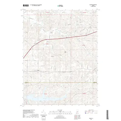
2019 Map of Koleen
USGS Topo · Published 2019About this map
Plummer Creek meanders through the central terrain of this Southern Indiana landscape, defining the topography between Koleen and the southern settlement of Doans. The area is characterized by significant elevations including Taylor Ridge and the aptly named Hard Scrabble Ridge, which have historically dictated the placement of homesteads and connector roads. Several family and community burial grounds are scattered throughout the hills, such as Robinson Cem, Duke Cem, and Howell Cem, offering vital location data for genealogists tracing ancestors in this part of Greene County. To the south, the terrain transitions toward the water resources of Greenwood Lake and Oberlin Lake, while springs like Rankin Spring and Rock Springs highlight the natural hydrology of the rural interior. The road network, including the Piankeshaw Trl, follows the winding paths established by the ridges and stream valleys.
Find a feature on this map
124 named features on this map. Tap any name to fly to it.
Don’t see what you’re looking for? This feature index may not catch every label — zoom into the map to look around manually.
Map Details
Editions of this 2019 Koleen Map
This is the sole edition of this map. No revisions or reprints were ever made.
Other maps of this area

1908 · Bloomington
USGS Topo · 1:48,000

1908 · Bloomfield
USGS Topo · 1:62,500

1910 · Bloomington
USGS Topo · 1:62,500

1935 · Oolitic
USGS Topo · 1:48,000

1942 · Oolitic
USGS Topo · 1:62,500

1950 · Odon
USGS Topo · 1:24,000

1951 · Bloomfield
USGS Topo · 1:24,000

1953 · Indianapolis
USGS Topo · 1:250,000

1956 · Indianapolis
USGS Topo · 1:250,000
1956 · Stanford
USGS Topo · 1:24,000