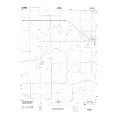
2009 Map of Konawa
USGS Topo · Published 2009About this map
The Canadian River cuts through the heart of this Oklahoma landscape, its wide channel and shifting banks defining the local topography between Seminole and Pontotoc counties. The town of Konawa serves as the primary settlement, positioned at the intersection of a dense network of sectional roads and the Oklahoma state highway system. This region is heavily characterized by its energy production history, visible through the presence of the Gray Oil Field, Grayson Oil Field, Bebee Oil Field, and Sledge Oil Field, which underscore the industrial importance of the area in the early 21st century.
Find a feature on this map
51 named features on this map. Tap any name to fly to it.
Don’t see what you’re looking for? This feature index may not catch every label — zoom into the map to look around manually.
Map Details
Editions of this 2009 Konawa Map
This is the sole edition of this map. No revisions or reprints were ever made.
Other maps of this area

1896 · Seminole and Prague
USGS Topo · 1:125,000

1901 · Stonewall
USGS Topo · 1:125,000

1907 · Maud
USGS Topo · 1:62,500

1908 · Maud
USGS Topo · 1:62,500

1954 · Oklahoma City
USGS Topo · 1:250,000

1957 · Ardmore
USGS Topo · 1:250,000

1957 · Oklahoma City
USGS Topo · 1:250,000
1958 · Pearson
USGS Topo · 1:24,000

1958 · Ada
USGS Topo · 1:24,000

1958 · Vamoosa
USGS Topo · 1:24,000