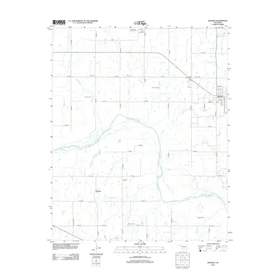
2012 Map of Konawa
USGS Topo · Published 2012About this map
Konawa sits near the eastern edge of this 2012 survey, where the grid of county roads meets the winding course of the Canadian River. This landscape reflects a deep intersection of religious history and industrial development, characterized by numerous burial grounds and active extraction fields. The northern territory is marked by the Sacred Heart Abbey Cemetery and Sacred Heart Cemetery, legacy sites of early mission work in Oklahoma. Scattered across the section lines are several oil operations, including the Gray Oil Field and Grayson Oil Field, while the southern reaches near Maxwell are defined by the convergence of Maxwell Creek and Buckhorn Creek as they feed into the river valley. Genealogists will find a high density of family-named landmarks and cemeteries, such as the Violet Springs Cemetery and Lyon's Cemetery, which anchor the local history of Seminole County.
Find a feature on this map
56 named features on this map. Tap any name to fly to it.
Don’t see what you’re looking for? This feature index may not catch every label — zoom into the map to look around manually.
Map Details
Editions of this 2012 Konawa Map
This is the sole edition of this map. No revisions or reprints were ever made.
Other maps of this area

1896 · Seminole and Prague
USGS Topo · 1:125,000

1901 · Stonewall
USGS Topo · 1:125,000

1907 · Maud
USGS Topo · 1:62,500

1908 · Maud
USGS Topo · 1:62,500

1954 · Oklahoma City
USGS Topo · 1:250,000

1957 · Ardmore
USGS Topo · 1:250,000

1957 · Oklahoma City
USGS Topo · 1:250,000
1958 · Pearson
USGS Topo · 1:24,000

1958 · Ada
USGS Topo · 1:24,000

1958 · Vamoosa
USGS Topo · 1:24,000