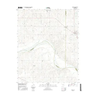
2016 Map of Konawa
USGS Topo · Published 2016About this map
The Canadian River defines the landscape of this region, winding through the southern half of the territory and serving as the boundary between Pottawatomie, Seminole, and Pontotoc counties. The settlement of Konawa serves as the primary local hub, while smaller communities like Sacred Heart and Maxwell anchor the surrounding rural sections. This 2016 survey is particularly valuable for genealogical research, documenting a high density of burial sites across the township, including the Sacred Heart Abbey Cem and several family or community grounds such as Vista Cem, Lyon's Cem, and Bates Cem. The terrain is drained by a network of local waterways like Young Cr, Maxwell Cr, and Jumper Cr, which flow into the larger river basin. To the northeast, the Salt Cr Site 46 Reservoir indicates modern water management, while the detailed road network, including Cemetery Hill Rd and St Louis Rd, reflects the area's established rural infrastructure.
Find a feature on this map
67 named features on this map. Tap any name to fly to it.
Don’t see what you’re looking for? This feature index may not catch every label — zoom into the map to look around manually.
Map Details
Editions of this 2016 Konawa Map
This is the sole edition of this map. No revisions or reprints were ever made.
Other maps of this area

1896 · Seminole and Prague
USGS Topo · 1:125,000

1901 · Stonewall
USGS Topo · 1:125,000

1907 · Maud
USGS Topo · 1:62,500

1908 · Maud
USGS Topo · 1:62,500

1954 · Oklahoma City
USGS Topo · 1:250,000

1957 · Ardmore
USGS Topo · 1:250,000

1957 · Oklahoma City
USGS Topo · 1:250,000
1958 · Pearson
USGS Topo · 1:24,000

1958 · Ada
USGS Topo · 1:24,000

1958 · Vamoosa
USGS Topo · 1:24,000