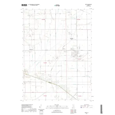
2019 Map of Kouts
USGS Topo · Published 2019About this map
Kouts serves as the central hub of this agricultural landscape in southern Porter County, where a dense network of drainage channels illustrates the extensive reclamation of the Kankakee Marsh. The Kankakee River defines the southern boundary, its course straightened and managed by an intricate system of waterways including Pleasant Township Ditch, Sandy Hook Ditch, and Cobb Ditch. These engineered features converted the once-vast wetlands into productive farmland, a transformation reflected in the grid of county roads and dispersed rural settlements like Aylesworth and Five Points Corner. For those tracing local heritage, several small burial grounds are documented, including Merriman Cem to the northwest and the Hopewell Mennonite Cem just west of the Kouts town center. The landscape remains defined by its hydraulic history, with numerous named ditches like Ahlgrim Ditch and Cook Ditch continuing to regulate the low-lying terrain.
Find a feature on this map
86 named features on this map. Tap any name to fly to it.
Don’t see what you’re looking for? This feature index may not catch every label — zoom into the map to look around manually.
Map Details
Editions of this 2019 Kouts Map
This is the sole edition of this map. No revisions or reprints were ever made.
Other maps of this area

1953 · Palmer
USGS Topo · 1:24,000

1953 · Wanatah
USGS Topo · 1:24,000

1953 · Hebron
USGS Topo · 1:24,000

1953 · Valparaiso
USGS Topo · 1:24,000

1953 · Kouts
USGS Topo · 1:24,000

1953 · Chicago
USGS Topo · 1:250,000

1957 · Chicago
USGS Topo · 1:250,000

1957 · Wheatfield
USGS Topo · 1:24,000

1957 · DeMotte
USGS Topo · 1:24,000

1958 · La Crosse
USGS Topo · 1:24,000