
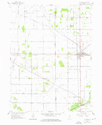
1958 Map of La Crosse
USGS Topo · Published 1959About this map
The rail junction at La Crosse serves as the focal point for this mid-century survey of the rural landscape where LaPorte, Porter, and Starke counties meet. This area was a critical nexus for industrial transport, evidenced by the convergence of the Pennsylvania Railroad, Monon Railroad, and the Chesapeake and Ohio. Small settlements like Clanricarde and Wilders dot these rail lines, while Riverside sits on the banks of the Kankakee River at the southern edge of the quadrangle.
Find a feature on this map
40 named features on this map. Tap any name to fly to it.
Don’t see what you’re looking for? This feature index may not catch every label — zoom into the map to look around manually.
Map Details
Editions of this 1958 La Crosse Map
2 editions found
Other maps of this area

1953 · Wanatah
USGS Topo · 1:24,000

1953 · Valparaiso
USGS Topo · 1:24,000

1953 · Kouts
USGS Topo · 1:24,000

1953 · Chicago
USGS Topo · 1:250,000

1957 · Chicago
USGS Topo · 1:250,000

1957 · Wheatfield
USGS Topo · 1:24,000

1958 · Hanna
USGS Topo · 1:24,000

1959 · English Lake
USGS Topo · 1:24,000

1959 · North Judson
USGS Topo · 1:24,000

1959 · San Pierre
USGS Topo · 1:24,000