
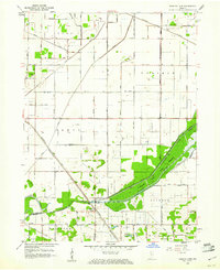
1959 Map of English Lake
USGS Topo · Published 1961About this map
The confluence of the Kankakee River and Yellow River anchors this landscape at the intersection of La Porte and Starke Counties. During the late 1950s, the terrain shows a heavily engineered hydrologic network, defined by an intricate system of drainage channels including the English Lake Ditch, Marsh Ditch, and Bessler Ditch. This infrastructure enabled the agricultural use of the low-lying prairie land surrounding the settlement of English Lake.
Find a feature on this map
51 named features on this map. Tap any name to fly to it.
Don’t see what you’re looking for? This feature index may not catch every label — zoom into the map to look around manually.
Map Details
Editions of this 1959 English Lake Map
2 editions found
Other maps of this area

1953 · Wanatah
USGS Topo · 1:24,000

1953 · Chicago
USGS Topo · 1:250,000

1957 · Chicago
USGS Topo · 1:250,000

1957 · Knox West
USGS Topo · 1:24,000

1958 · La Crosse
USGS Topo · 1:24,000

1958 · Hanna
USGS Topo · 1:24,000

1958 · Kingsford Heights
USGS Topo · 1:24,000

1959 · North Judson
USGS Topo · 1:24,000

1959 · San Pierre
USGS Topo · 1:24,000

1962 · Denham
USGS Topo · 1:24,000