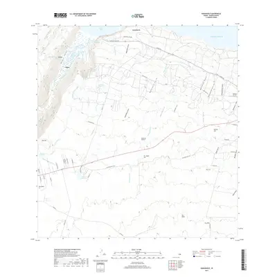
2017 Map of Kukuihaele
USGS Topo · Published 2017About this map
Waipio Valley dominates the northwestern coastal landscape, where steep terrain meets the Pacific Ocean at Waipio Bay. This modern survey illustrates the complex water management systems of the Hamakua Coast, including the Upper Hamakua Ditch and Lower Hamakua Ditch, which historically supported agricultural irrigation across the island. The settlement of Kukuihaele sits near the valley's rim, while residential developments like Kawela Loa and several reservoirs, such as Lalakea Reservoir and Pyukapu Reservoir, are scattered across the rising elevations. Local history and genealogy researchers can locate family-named landmarks and peaks including Puu Lala and Puu Ohia, as well as the coastal Lalakea Fishpond. A dense network of gulches, such as Waikoehoe Gulch and Malanahoe Gulch, carves through the landscape, defining the drainage patterns toward the sea.
Find a feature on this map
63 named features on this map. Tap any name to fly to it.
Don’t see what you’re looking for? This feature index may not catch every label — zoom into the map to look around manually.
Map Details
Editions of this 2017 Kukuihaele Map
This is the sole edition of this map. No revisions or reprints were ever made.
Other maps of this area

1915 · Hamakua
USGS Topo · 1:62,500

1916 · Waipio
USGS Topo · 1:62,500

1954 · Hawaii North
USGS Topo · 1:250,000

1956 · Kamuela
USGS Topo · 1:24,000

1956 · Nohonaohae
USGS Topo · 1:24,000

1956 · Makahalau
USGS Topo · 1:24,000

1956 · Umikoa
USGS Topo · 1:24,000
1957 · Honokane
USGS Topo · 1:24,000

1957 · Honokaa
USGS Topo · 1:24,000

1959 · Hawaii North
USGS Topo · 1:250,000