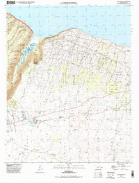
1995 Map of Kukuihaele
USGS Topo · Published 1998About this map
Waipio Valley and the northern coast of the Big Island define this landscape, where steep cliffs meet the Pacific Ocean. The settlement of Kukuihaele serves as a primary hub above the coastal bluffs, overlooking Kukuihaele Landing and a local Lighthouse. The terrain is deeply incised by numerous streams and spectacular waterfalls, including Hiilawe Falls, Kaluahine Falls, and Nanaue Falls. Inland, the map reveals the complex infrastructure of the Hamakua coast's agricultural history, evidenced by the Puu Kikoni Dairy, several plantation-era camps like Camp 106 and Camp Honokala, and an extensive network of water management features. The Kohala Watershed Boundary and various reservoirs, such as Puukapu Reservoir and the Ululani Reservoir, underscore the vital role of water collection for the surrounding Puukapu Homesteads and Kaauhuhu Homesteads.
Find a feature on this map
82 named features on this map. Tap any name to fly to it.
Don’t see what you’re looking for? This feature index may not catch every label — zoom into the map to look around manually.
Map Details
Editions of this 1995 Kukuihaele Map
This is the sole edition of this map. No revisions or reprints were ever made.
Other maps of this area

1915 · Hamakua
USGS Topo · 1:62,500

1916 · Waipio
USGS Topo · 1:62,500

1954 · Hawaii North
USGS Topo · 1:250,000

1956 · Kamuela
USGS Topo · 1:24,000

1956 · Nohonaohae
USGS Topo · 1:24,000

1956 · Makahalau
USGS Topo · 1:24,000

1956 · Umikoa
USGS Topo · 1:24,000
1957 · Honokane
USGS Topo · 1:24,000

1957 · Honokaa
USGS Topo · 1:24,000

1959 · Hawaii North
USGS Topo · 1:250,000