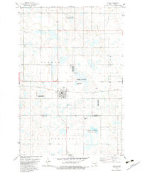
1982 Map of Kulm
USGS Topo · Published 1983About this map
Kulm serves as the central hub of this prairie landscape, where the grain-hauling tracks of the Soo Line railroad bisect the township of Norden. The map reveals a deeply rooted rural community, evidenced by several denominationally or ethnic-aligned burial grounds including Norwegian Cem, American Cem, Gradenfeld Cem, and United Cem. The terrain is defined by a dense network of seasonal wetlands and prairie potholes, many of which are protected within the extensive National Waterfowl Production Area. Local infrastructure at the start of the 1980s includes the Pruetz Municipal Airport and small-scale industrial sites such as a Gravel Pit, reflecting a landscape dedicated to both agriculture and conservation. The boundary between La Moure and Dickey counties runs through the southern section, anchoring several family-named landmarks and township divisions.
Find a feature on this map
18 named features on this map. Tap any name to fly to it.
Don’t see what you’re looking for? This feature index may not catch every label — zoom into the map to look around manually.
Map Details
Editions of this 1982 Kulm Map
This is the sole edition of this map. No revisions or reprints were ever made.
Other maps of this area

1896 · Edgeley
USGS Topo · 1:125,000

1925 · Edgeley
USGS Topo · 1:125,000

1953 · Jamestown
USGS Topo · 1:250,000

1956 · Jamestown
USGS Topo · 1:250,000

1971 · Merricourt
USGS Topo · 1:24,000

1971 · Merricourt NW
USGS Topo · 1:24,000

1982 · Coldwater Lake NE
USGS Topo · 1:24,000

1982 · Fredonia
USGS Topo · 1:24,000

1982 · Schlecht-Weixel Dam
USGS Topo · 1:24,000

1982 · Deisem
USGS Topo · 1:24,000