1984 Map of Kumiva Peak
USGS Topo · Published 1984About this map
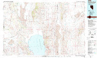
Pyramid Lake and its distinctive features, including Enchanted Wizards Cove and Thunderbolt Bay, dominate the southern reach of this Basin and Range landscape. The Pyramid Lake Indian Reservation encompasses these waters, which are flanked by the Virginia Mountains and the Fox Range. To the west, the Southern Pacific and Western Pacific railroads trace the edge of Honey Lake Valley, passing through the junction at Flanigan. The map reveals a complex hydrologic system where seasonal sinks like the Smoke Creek Desert and the alkali expanse of Winnemucca Lake sit between prominent heights like Kumiva Peak and Mt Limbo. From the Doyle State Wildlife Area on the California border to the remote Mines of the Nightingale Mountains, the area is defined by its isolated wells, springs, and desert flats.
Find a feature on this map
75 named features on this map. Tap any name to fly to it.
Don’t see what you’re looking for? This feature index may not catch every label — zoom into the map to look around manually.
Map Details
Editions of this 1984 Kumiva Peak Map
This is the sole edition of this map. No revisions or reprints were ever made.
Other maps of this area

1886 · Honey Lake
USGS Topo · 1:250,000

1886 · Granite Range
USGS Topo · 1:250,000

1890 · Wadsworth
USGS Topo · 1:125,000

1890 · Sierraville
USGS Topo · 1:125,000

1891 · Honey Lake
USGS Topo · 1:250,000

1891 · Reno
USGS Topo · 1:125,000

1892 · Wadsworth
USGS Topo · 1:125,000

1892 · Sierraville
USGS Topo · 1:125,000

1893 · Honey Lake
USGS Topo · 1:250,000

1893 · Reno
USGS Topo · 1:125,000