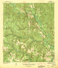
1942 Map of Kushla
USGS Topo · Published 1942About this map
Chickasaw Creek defines the eastern edge of this Alabama landscape, its winding course and associated wetlands creating a natural boundary for the settlements of Kushla and Mauvilla. Surveyed just before the United States entered the second World War, the map reveals a rural economy organized around the Gulf Mobile and Ohio Railroad and a network of named trails like Spice Pond Road. Small community hubs are identified by their spiritual and educational centers, including Mt Pilgrim Ch and the Kushla Sch. The elevation changes around Smithtown and the various branches of Williams Creek show a rugged terrain that influenced the placement of cemeteries like Mauvilla Cem and Indian Springs Cem on higher ground. This document provides a clear view of the Mobile County backcountry before the post-war expansion of the Gulf Coast region.
Find a feature on this map
28 named features on this map. Tap any name to fly to it.
Don’t see what you’re looking for? This feature index may not catch every label — zoom into the map to look around manually.
Map Details
Editions of this 1942 Kushla Map
2 editions found
Other maps of this area

1922 · Mobile
USGS Topo · 1:62,500

1940 · Mobile
USGS Topo · 1:31,680

1940 · Mobile
USGS Topo · 1:62,500

1941 · Chickasaw
USGS Topo · 1:31,680

1941 · Hurley
USGS Topo · 1:62,500

1941 · Creola
USGS Topo · 1:62,500

1942 · Kushla
USGS Topo · 1:31,680

1942 · Wilmer
USGS Topo · 1:62,500

1943 · Creola
USGS Topo · 1:62,500

1943 · Chickasaw
USGS Topo · 1:31,680