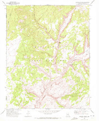
1970 Map of Kydestea Spring
USGS Topo · Published 1972About this map
Kydestea Spring sits within a landscape defined by the Navajo Hopi Joint Use Area and the dramatic relief of Black Mesa in northern Arizona. This 1970 survey shows a region where water sources are vital landmarks, as seen in the locations of Dog Spring, Cottonwood Spring, and the prominent Blue Canyon to the south. The drainage patterns of Coal Mine Wash and Moenkopi Wash illustrate the erosive forces that have carved this portion of the Navajo reservation.
Find a feature on this map
13 named features on this map. Tap any name to fly to it.
Don’t see what you’re looking for? This feature index may not catch every label — zoom into the map to look around manually.
Map Details
Editions of this 1970 Kydestea Spring Map
This is the sole edition of this map. No revisions or reprints were ever made.
Other maps of this area

1883 · Marsh Pass
USGS Topo · 1:250,000

1892 · Marsh Pass
USGS Topo · 1:250,000

1956 · Marble Canyon
USGS Topo · 1:250,000

1959 · Marble Canyon
USGS Topo · 1:250,000

1961 · Marble Canyon
USGS Topo · 1:250,000
1967 · Rocky Ridge NW
USGS Topo · 1:24,000
1967 · Pillars of Hercules
USGS Topo · 1:24,000
1967 · Rocky Ridge NE
USGS Topo · 1:24,000

1970 · Cow Springs
USGS Topo · 1:24,000

1970 · Black Mesa Wash NW
USGS Topo · 1:24,000