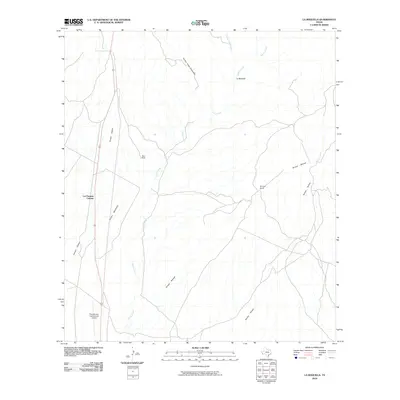
2010 Map of La Boquilla
USGS Topo · Published 2010About this map
Las Pampas Colonia and the surrounding desert ranchlands of Presidio County are defined by a complex network of seasonal drainages and isolated outposts. In this high-desert environment, life and transit center on arroyos like Arroyo Chillon and Arroyo Mimbroso, which carve through the landscape toward the prominent Cibolo Creek. The presence of Twin Mills and Arroyos Ranch suggests the persistent footprint of cattle ranching in a region where water sources such as Arroyo Tinaja Escondido are vital landmarks. Transportation and infrastructure are anchored by the Presidio Lely International Airport in the southwest corner, while the settlement of La Boquilla sits near the confluence of several northern drainages, including Morita Creek. This map reveals the intersection of modern aviation and traditional desert land use in the Big Bend region.
Find a feature on this map
13 named features on this map. Tap any name to fly to it.
Don’t see what you’re looking for? This feature index may not catch every label — zoom into the map to look around manually.
Map Details
Editions of this 2010 La Boquilla Map
This is the sole edition of this map. No revisions or reprints were ever made.
Other maps of this area

1896 · Shafter
USGS Topo · 1:125,000

1959 · Presidio
USGS Topo · 1:250,000

1965 · Presidio
USGS Topo · 1:250,000

1978 · La Boquilla
USGS Topo · 1:24,000
1979 · Presidio West
USGS Topo · 1:24,000

1979 · Presidio East
USGS Topo · 1:24,000

1980 · Arroyo Melado
USGS Topo · 1:24,000

1983 · Shafter
USGS Topo · 1:24,000

1983 · Cerro Redondo
USGS Topo · 1:24,000

1983 · Cienega Mountains
USGS Topo · 1:24,000