Loading...
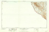
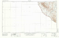
Loading map...1965 Map of Presidio
USGS Topo · Published 1965About this map
The United States Mexico border follows the winding course of the Rio Grande through this high desert region of Presidio County. The landscape is dominated by the Chinati Mountains, where Chinati Peak rises above a territory marked by industrial extraction and remote ranching. Mining history is evident near the mountain slopes at the Shafter Mine and Last Chance Mine, reflecting the region's legacy of silver and lead production.
Find a feature on this map
32 named features on this map. Tap any name to fly to it.
Don’t see what you’re looking for? This feature index may not catch every label — zoom into the map to look around manually.
Map Details
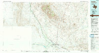
Date Portrayed1965
Date Published1965
PublisherU.S. Geological Survey
Map TypeTopographic
Scale1:250,000
Physical Dimensions34 x 22.1 inches
Editions of this 1965 Presidio Map
This is the sole edition of this map. No revisions or reprints were ever made.
Historical Maps of Presidio Through Time
4 maps found
Featured Locations
Source Details
SourceU.S. Geological Survey
CopyrightPublic Domain