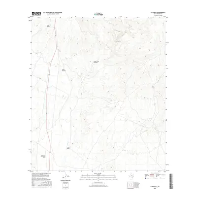
2016 Map of La Boquilla
USGS Topo · Published 2016About this map
Cibolo Cr and its complex network of ephemeral drainages dominate this Presidio County landscape, where water has carved deep paths through the high desert. The small settlement of La Boquilla sits near the confluence of Morita Cr and Cibolo Cr, illustrating the vital connection between water sources and habitation in this arid region. The topographical data reveals a series of significant arroyos, including Arroyo Tinaja Escondido and Arroyo Melado, which define the drainage patterns and landforms of the area. To the southwest, the Presidio Lely International Airport stands as a primary modern infrastructure point, linked to the surrounding territory by Garcia Rd. The map provides a detailed record of named desert landmarks and geographical features such as Arroyo Chillon and Arroyo Mimbroso, essential for understanding local hydrology and land use near the border.
Find a feature on this map
12 named features on this map. Tap any name to fly to it.
Don’t see what you’re looking for? This feature index may not catch every label — zoom into the map to look around manually.
Map Details
Editions of this 2016 La Boquilla Map
This is the sole edition of this map. No revisions or reprints were ever made.
Other maps of this area

1896 · Shafter
USGS Topo · 1:125,000

1959 · Presidio
USGS Topo · 1:250,000

1965 · Presidio
USGS Topo · 1:250,000

1978 · La Boquilla
USGS Topo · 1:24,000
1979 · Presidio West
USGS Topo · 1:24,000

1979 · Presidio East
USGS Topo · 1:24,000

1980 · Arroyo Melado
USGS Topo · 1:24,000

1983 · Shafter
USGS Topo · 1:24,000

1983 · Cerro Redondo
USGS Topo · 1:24,000

1983 · Cienega Mountains
USGS Topo · 1:24,000