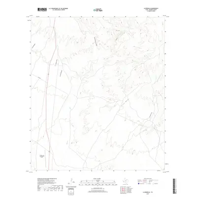
2019 Map of La Boquilla
USGS Topo · Published 2019About this map
Cibolo Cr and its network of dry washes define this arid landscape in the Big Bend region of West Texas. This 2019 survey provides a modern record of the drainage patterns carved by Arroyo Melado, Arroyo Chillon, and Arroyo Mimbroso as they feed into the larger creek system. The map reflects a sparsely developed area where transportation is primarily dictated by the terrain, featuring Garcia Rd and a few secondary routes that cross the desert floor. In the southwestern corner, the Presidio Lely International Airport stands as the most significant landmark, serving as a hub for aerial navigation near the international border. The elevation contours illustrate the transition from the relatively flat valley floor toward the upland canyons of La Boquilla and the eastern ridges drained by Arroyo Tortola.
Find a feature on this map
12 named features on this map. Tap any name to fly to it.
Don’t see what you’re looking for? This feature index may not catch every label — zoom into the map to look around manually.
Map Details
Editions of this 2019 La Boquilla Map
This is the sole edition of this map. No revisions or reprints were ever made.
Other maps of this area

1896 · Shafter
USGS Topo · 1:125,000

1959 · Presidio
USGS Topo · 1:250,000

1965 · Presidio
USGS Topo · 1:250,000

1978 · La Boquilla
USGS Topo · 1:24,000
1979 · Presidio West
USGS Topo · 1:24,000

1979 · Presidio East
USGS Topo · 1:24,000

1980 · Arroyo Melado
USGS Topo · 1:24,000

1983 · Shafter
USGS Topo · 1:24,000

1983 · Cerro Redondo
USGS Topo · 1:24,000

1983 · Cienega Mountains
USGS Topo · 1:24,000