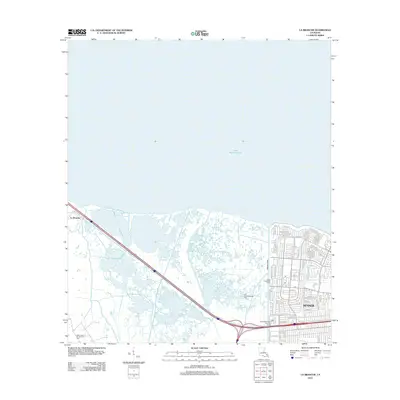
2012 Map of La Branche
USGS Topo · Published 2012About this map
Lake Pontchartrain dominates the northern reaches of this coastal landscape, where the marshy terrain of Jefferson Parish meets the edge of suburban development. The transition from wetlands to the established neighborhoods of Kenner is clearly defined by drainage and flood control infrastructure, including the Duncan Canal and the Upper Protection Levee. In the west, the settlement of La Branche sits near the mouth of Bayou La Branche, illustrating the historical dependence on natural waterways before the modern expansion of the city's residential grid. Industrial footprints are visible in the surrounding wetlands through the East Good Hope Gas Field and the Good Hope Oil and Gas Field, highlighting the region's energy production history. The southern portion of the map shows the dense residential street network of Kenner, including Woodlake Blvd and Joe Yenni Blvd, reaching toward the lakefront.
Find a feature on this map
74 named features on this map. Tap any name to fly to it.
Don’t see what you’re looking for? This feature index may not catch every label — zoom into the map to look around manually.
Map Details
Editions of this 2012 La Branche Map
This is the sole edition of this map. No revisions or reprints were ever made.
Other maps of this area

1891 · Hahnville
USGS Topo · 1:62,500

1891 · Spanish Fort
USGS Topo · 1:62,500

1891 · New Orleans
USGS Topo · 1:62,500

1892 · Bonnet Carre
USGS Topo · 1:62,500

1932 · New Orleans NW
USGS Topo · 1:31,680

1932 · Hahnville NW
USGS Topo · 1:31,680

1932 · Hahnville NE
USGS Topo · 1:31,680

1935 · Laplace
USGS Topo · 1:31,680

1935 · Luling
USGS Topo · 1:31,680

1936 · Hahnville
USGS Topo · 1:31,680