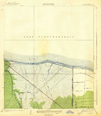
1938 Map of La Branche
USGS Topo · Published 1938About this map
Lake Pontchartrain dominates the northern horizon of this 1930s coastal survey, revealing a landscape defined by the intricate management of water and transit in St. Charles and Jefferson Parishes. The settlement of Labranche serves as a focal point where the Illinois Central railroad cuts through the wetlands. This era of mapping highlights the massive infrastructure projects of the time, specifically the Bonnet Carre Floodway and the West Boundary of Kenner Protection Levee, which were engineered to protect the region from the unpredictable rise of the Mississippi River.
Find a feature on this map
20 named features on this map. Tap any name to fly to it.
Don’t see what you’re looking for? This feature index may not catch every label — zoom into the map to look around manually.
Map Details
Editions of this 1938 La Branche Map
2 editions found
Other maps of this area

1891 · Hahnville
USGS Topo · 1:62,500

1891 · Spanish Fort
USGS Topo · 1:62,500

1891 · New Orleans
USGS Topo · 1:62,500

1892 · Bonnet Carre
USGS Topo · 1:62,500

1932 · New Orleans NW
USGS Topo · 1:31,680

1932 · Hahnville NW
USGS Topo · 1:31,680

1932 · Hahnville NE
USGS Topo · 1:31,680

1935 · Laplace
USGS Topo · 1:31,680

1935 · Luling
USGS Topo · 1:31,680

1936 · Hahnville
USGS Topo · 1:31,680