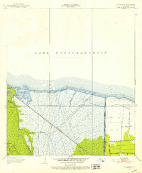
1952 Map of La Branche
USGS Topo · Published 1953About this map
The marshy lowlands of St. Charles Parish meet the southern shores of Lake Pontchartrain in this mid-century survey of the Mississippi River delta region. The landscape is defined by the intersection of natural drainage and human engineering, featuring a complex network of waterways like Bayou La Branche and Bayou Piquant alongside the industrial presence of an Oil Field. Significant civil works dominate the western and eastern portions of the sheet, notably the Bonnet Carre Floodway and the West Boundary of Kenner Protection Levee, illustrating the era's intensive flood control efforts. The Illinois Central railroad cuts a straight diagonal across the wetlands, providing a critical transport link near the small settlement of La Branche. The map also captures the meticulously numbered drainage systems, such as Canal No 7 and Canal No 17, which reflect the systematic attempt to manage this water-bound environment.
Find a feature on this map
23 named features on this map. Tap any name to fly to it.
Don’t see what you’re looking for? This feature index may not catch every label — zoom into the map to look around manually.
Map Details
Editions of this 1952 La Branche Map
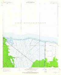
2 editions found
Other maps of this area

1891 · Hahnville
USGS Topo · 1:62,500

1891 · Spanish Fort
USGS Topo · 1:62,500

1891 · New Orleans
USGS Topo · 1:62,500

1892 · Bonnet Carre
USGS Topo · 1:62,500

1932 · New Orleans NW
USGS Topo · 1:31,680

1932 · Hahnville NW
USGS Topo · 1:31,680

1932 · Hahnville NE
USGS Topo · 1:31,680

1935 · Laplace
USGS Topo · 1:31,680

1935 · Luling
USGS Topo · 1:31,680

1936 · Hahnville
USGS Topo · 1:31,680