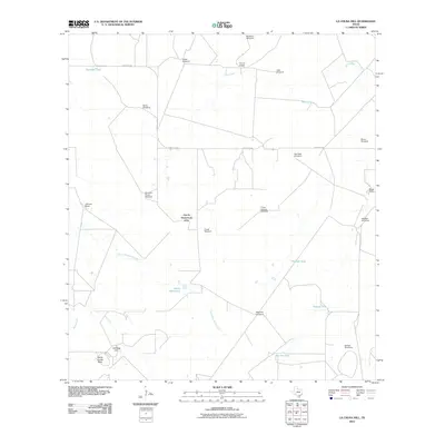
2010 Map of La Chusa Hill
USGS Topo · Published 2010About this map
Encino Ranch and Lachusa Ranch anchor this portion of McMullen County, where the arid landscape is defined by the critical infrastructure of cattle ranching. The map reveals a sophisticated network of water management, relying on numerous cattle tanks such as Gueydan Tank and Pipeline Tank to sustain livestock. A significant number of named windmills, including the Gueydan House Windmill, Three Corners Windmill, and the Bartlett Windmills, illustrate the reliance on groundwater in this South Texas environment. The terrain is marked by distinctive elevations like LaChusa Hill and Devils Center Table, while drainage is managed by ephemeral systems such as Devils Waterhole Creek and Hill Creek. This survey provides a precise look at the rural land divisions and the spatial distribution of ranching outposts like Rhode Ranch as they existed in the early 21st century.
Find a feature on this map
29 named features on this map. Tap any name to fly to it.
Don’t see what you’re looking for? This feature index may not catch every label — zoom into the map to look around manually.
Map Details
Editions of this 2010 La Chusa Hill Map
This is the sole edition of this map. No revisions or reprints were ever made.
Other maps of this area

1920 · Mikeska
USGS Topo · 1:125,000

1929 · Simmons
USGS Topo · 1:62,500

1930 · Tilden
USGS Topo · 1:62,500

1937 · Loma Alta
USGS Topo · 1:62,500

1942 · Tilden
USGS Topo · 1:62,500

1953 · Crystal City
USGS Topo · 1:250,000

1955 · Crystal City
USGS Topo · 1:250,000

1961 · Crystal City
USGS Topo · 1:250,000

1968 · Crystal City
USGS Topo · 1:250,000
1969 · Live Oak Hollow
USGS Topo · 1:24,000